


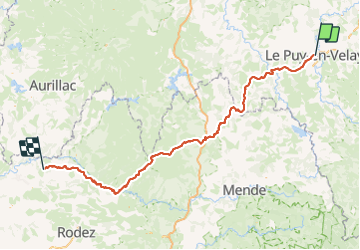
SAINT JACQUES DE COMPOSTELLE: LE PUY EN VELAY - CONQUES

djeepee74
User

Length
218 km

Max alt
1368 m

Uphill gradient
5274 m
Km-Effort
289 km

Min alt
290 m

Downhill gradient
5596 m
Boucle
No
Creation date :
2023-06-09 15:47:45.659
Updated on :
2023-06-09 16:55:09.593
66h00
Difficulty : Difficult

FREE GPS app for hiking
 SityTrail
IGN / Geographical institutes
SityTrail Plus
The world is yours!
About
Trail Walking of 218 km to be discovered at Auvergne-Rhône-Alpes, Haute-Loire, Le Puy-en-Velay. This trail is proposed by djeepee74.
Description
live du 28 mai au 06 juin 2023...
soit 10 jours de marche... et 66 heures en déplacement.
Positioning
Country:
France
Region :
Auvergne-Rhône-Alpes
Department/Province :
Haute-Loire
Municipality :
Le Puy-en-Velay
Location:
Unknown
Start:(Dec)
Start:(UTM)
569956 ; 4988114 (31T) N.
Comments